I’ve driven the red-rock highways of Utah more times than I can count…seven trips over the years, hitting every single national park in the state. From watching sunrise paint the hoodoos in Bryce Canyon to standing on the edge of Canyonlands’ endless cliffs, I’ve learned exactly how to squeeze the most magic out of a Utah road trip.
Up until now, this itinerary has been my private playbook. The one I’ve shared only with close friends and family who’ve called asking, “You’ve done Utah a million times… what’s the real best route?” It’s a mix of big, bucket-list moments and the quieter stops most travelers blow past. Whether it’s your first trip or your fifth, this guide will walk you through the ultimate loop…the routes, the stops, the timing, and all the small details that turn a road trip into a trip you’ll be talking about for the rest of your life.
Making the Most Incredible Utah National Park Road Trip
Planning a Utah road trip can feel like trying to drink from a firehose. The state is huge, the landscapes are wildly different from one corner to the next, and every stop could easily eat up a full day. Over the years, I’ve found that a loop — starting and ending in Salt Lake City — gives you the best mix of scenery without backtracking too much.
Here’s the cheat sheet I wish I had before my first trip:
How long to go
- 7 days: Zion, Bryce, Capitol Reef — fast, but still gorgeous.
- 10 days: Add Arches and Canyonlands for the full “Mighty 5.”
- 14+ days: You’ve got time for Grand Staircase, Goblin Valley, Bears Ears, and Natural Bridges — the under-the-radar spots that blew me away.
Best time to go
- April–early June / September–October: Warm days, cool nights, and fewer storms.
- Summer: Manageable if you start hikes at sunrise and take a midday siesta.
- Winter: Peaceful, with Bryce’s hoodoos dusted in snow — just pack microspikes for icy trails.
Passes and permits
- Grab an America the Beautiful Pass. It pays for itself by your second park.
- Angels Landing is my favorite hike in Zion, but you’ll need a permit lottery win. The Narrows depends on safe water levels.
- Arches often runs timed entry in peak months — reserve early.
Vehicle
- A high-clearance SUV is best — you don’t need 4×4 for the main parks, but it’s a game-changer if you’re heading into Grand Staircase or Cathedral Valley after rain.
Logistics that save you time
- Download offline maps on Google Maps and AllTrails — service is spotty.
- Carry 4 liters of water per person on hot days.
- Fill your tank in bigger towns. Between parks, gas stations are rare.

Road Trip Itinerary Map for Utah National Parks
Use my map below to see the full loop, gas stops, and my favorite trailheads. I pre-download it to my phone so it works without service.
Now, here’s my epic Utah itinerary, from the soaring cliffs of Zion to the unique rock formations of Arches.
Days 1-2: Salt Lake City
Salt Lake City is where every one of my Utah road trips has started. It’s big enough to stock up on gear and road snacks, yet close enough to the mountains that you can be on a hiking trail within 20 minutes of landing. I usually give myself at least a full day here…partly to shake off travel fatigue, partly because SLC has more going on than most people realize.
One trip, I landed late and headed straight for Antelope Island State Park the next morning. The sun was just coming up, lighting the lake in gold, and a herd of bison wandered right across the road like they owned it. Another time, I spent an afternoon wandering the shaded paths at Red Butte Garden, just to ease into “vacation mode” before tackling the desert heat further south.

Salt Lake City Bucket List:
- Temple Square: Whether you’re drawn by the architecture or the history, this is SLC’s most iconic spot. If you’re lucky, you might catch the Tabernacle Choir rehearsing.
- Great Salt Lake & Antelope Island: For sweeping views, salty breezes, and a good chance of spotting bison. The island’s hiking trails are perfect for a half-day escape.
- City Creek Center: My go-to for last-minute gear or a bite to eat before hitting the road. Bonus — it’s open-air, so you’re not stuck under fluorescent lights.
- Red Butte Garden: Spring and summer bring an explosion of color here. If you’re in town during a concert night, it’s a magical setting for live music.
- Utah State Capitol: Free tours, marble columns, and one of the best views over the city.
Before leaving, I always stock up on water jugs, snacks, and a bag of trail mix big enough to last until Moab. If you need outdoor gear, the local REI or smaller shops like Wasatch Touring can set you up with anything from trekking poles to river shoes for The Narrows.
Alternative Idea: Day Trips from SLC
If you’ve got extra time before heading south, the mountains, lakes, and canyons around Salt Lake City make for some unforgettable detours. I’ve used these as “warm-up” days before starting my loop, giving myself a taste of Utah’s landscapes without yet committing to the long drives.
✈️ My #1 Hack for Cheap 2026 Flights:
It’s spring, so flight prices are climbing fast - but you don't have to pay them. I’m currently seeing roundtrips to Europe for under $300 (deals you won’t find on Google Flights).
Step 1: Join Going.com's Free Plan here. It takes 10 seconds and requires no credit card.
Step 2: If you're doing a big trip this year, grab the 14-day free trial of Premium. You can even use my code JON25 for 25% off.
Seriously, this is the single best money-saving tool I’ve used in 9+ years.
👉 Send me cheap 2026 flights1. Antelope Island State Park
The first time I drove onto Antelope Island, I ended up pulling over every five minutes…bison in the road, pelicans skimming the water, and that endless mirror of the Great Salt Lake stretching toward the horizon. The island’s Buffalo Point Trail is short but delivers a killer sunset view.
2. Park City
Just 30 minutes from downtown, Park City’s main street has that cozy ski-town charm even in summer. I once rode the Alpine Slide here in July, then grabbed a coffee at a sidewalk café and watched mountain bikers zip past on the chairlifts.
3. Bonneville Salt Flats
It’s hard to explain just how big the Salt Flats feel until you’re standing in the middle of that blinding white expanse. If you’re lucky, you’ll catch them after rain when the surface turns into a perfect mirror — it’s surreal.
4. Big Cottonwood Canyon
When I need a quick mountain escape, this is where I go. The hike to Lake Blanche is a workout, but the reward is an alpine lake backed by Sundial Peak. In fall, the aspens turn gold and the whole canyon glows.
5. Mirror Lake Scenic Byway
This 42-mile drive into the Uinta Mountains is my go-to summer cool-off. Pack a picnic and stop at Provo River Falls. I’ve dipped my feet in the icy water here more times than I can count.
6. Timpanogos Cave National Monument
The cave system is incredible, but I’ll be honest…the steep switchback hike to get there is half the adventure. Bring water and take your time; the views over American Fork Canyon are worth every step.
7. Snowbird
Even in July, you can ride the aerial tram up to Hidden Peak for alpine views that stretch into three states. I once spent an entire day here riding the mountain coaster, hiking wildflower trails, and finishing with a plate of tacos on the deck at dusk.

Days 3-6: Zion National Park
Zion National Park is where the trip shifts into high gear. After the drive south from Salt Lake City, the red cliffs rise up around you like a giant stone gateway. I still remember the first time I rolled into Springdale. The late afternoon light was bouncing off the canyon walls, and I thought, “Yep… this is going to be good.”
I usually base myself in Springdale because it puts you right at the park entrance. I consider it one of the most beautiful towns in the US – from virtually every hotel in town, you’ll have incredible views of the region’s red rocks. You can roll out of bed, grab a coffee at Deep Creek Coffee Co., and be on a shuttle headed up-canyon within minutes.
Coolest Experiences in Zion National Park
- Angel’s Landing: This is the hike everyone talks about, and for good reason. The 4.3-mile trail is steep and includes sections with chains for support. Start early in the morning to avoid the midday heat and crowds. You’ll need to reserve a permit online in advance.
- The Narrows: Wading through the Virgin River with sheer canyon walls on either side is like stepping into another world. This slot canyon hike is also one of my favorites in the park. Rent water shoes and a walking stick from a local outfitter to navigate the slippery rocks. The first time I did this hike, the water was waist-deep and icy even in July, but I couldn’t stop grinning.
- Canyon Overlook Trail: When I want a big view without burning a whole day, this is my go-to. A one-mile round trip, and you’re standing on a ledge looking straight down Zion Canyon. Go at sunrise for soft light and cooler temps.
More Must-See Sights
- Emerald Pools: Lower, Middle, and Upper Pools all have their own vibe. I love the misty waterfall at the Lower Pool on a hot day — it’s like walking through nature’s air conditioner.
- Riverside Walk: Paved, shaded, and perfect for an easy evening stroll when the canyon walls are glowing orange.
- Kolob Canyons: This corner of the park is quieter, with deep red cliffs and fewer people. The scenic drive is gorgeous, and the hikes here feel like hidden treasures.
Tip: If you’re camping, Watchman Campground is my top pick, as it’s walking distance to the visitor center and the shuttle. Book early. If you want something more rustic, backcountry sites offer the kind of starry nights you’ll remember years later.
- Read my guide: Top Bucket List Attractions in Zion National Park

Days 7-8: Bryce Canyon National Park
Driving from Zion to Bryce feels like changing planets. One minute you’re winding through red cliffs and cottonwoods, the next you’re standing at 8,000 feet staring down into a sea of hoodoos…those wild, spire-shaped rock formations Bryce is famous for. The air here is crisp, even in midsummer, and the colors shift from deep orange to pale pink as the light changes. It’s an absolute must-see on a Southwest road trip.
I’ve done Bryce as both a quick day trip and a slow, two-night stay. Even with a single day, you can catch sunrise, hike the canyon, and still have time for a scenic drive. But if you have the time, stay overnight…the stargazing here is on another level. One August night, I lay on my back in the main amphitheater parking lot and watched meteors streak across the Milky Way.
Bryce Canyon Bucket List
- Sunrise Point and Sunset Point: Yes, the names are obvious, but they’re perfectly placed. My favorite move is sunrise at Sunrise Point — where the first light catches the tops of the hoodoos — then walk the rim trail to Sunset Point while the canyon wakes up.
- Navajo Loop Trail: My #1 Bryce hike. You drop down between sheer orange walls into Wall Street, a slot canyon with ponderosa pines growing impossibly tall in the narrow space. Climbing past Thor’s Hammer on the way up never gets old.
- Queen’s Garden Trail: Connect this with the Navajo Loop for a longer, more immersive hike. Look for the rock that really does look like Queen Victoria — once you see it, you can’t unsee it.
- Bryce Point: If you’re here at sunset, this is the place to be. The amphitheater spreads out below you, and the hoodoos seem to catch fire in the evening light.
- Fairyland Loop: Eight miles of quieter trails where you can wander among hoodoos without the crowds. I once had an entire stretch of the trail to myself for over an hour.
My Tip: The free park shuttle is your best friend in peak season. Parking fills up fast, and the shuttle will drop you right at the major viewpoints and trailheads.

Days 9-11: Grand Staircase-Escalante National Monument
This is where the trip starts to feel truly wild. Grand Staircase–Escalante is huge and rugged, with more canyons and hidden rock formations than you could explore in a lifetime. I remember my first time driving the stretch of Highway 12 between Escalante and Boulder. It felt like the road was floating between two endless drop-offs, with slickrock and desert stretching as far as I could see.
I usually base myself in Escalante because it has a few solid restaurants, a good outfitter, and easy access to most trailheads. Boulder is another great choice, especially if you plan to spend more time on the Burr Trail. These are some of the most unique places to stay in Utah.
My Favorite Spots in Grand Staircase–Escalante
- Lower Calf Creek Falls: The first time I hiked this, it was late spring and the desert was already warm. Six miles later, stepping under that 126-foot waterfall felt like walking into air conditioning. The water is shockingly cold, which makes it even better.
- Devil’s Garden: A playground of hoodoos and arches that feels like it was designed by a sculptor with a sense of humor. It is right off Hole-in-the-Rock Road, so you can wander here without a long hike.
- Peek-a-Boo and Spooky Slot Canyons: Tight squeezes, twisting walls, and the occasional scramble make this one of the most fun hikes in Utah. Go in spring or fall when the temperatures are manageable and be prepared to get dusty.
More Unique Stops
- Escalante Petrified Forest State Park: Short trails wind past ancient, crystallized logs and open up to big views over Wide Hollow Reservoir.
- Burr Trail: A scenic drive with switchbacks carved into the canyon walls. I have pulled over so many times on this road just to stand there and take it all in.
- Hole-in-the-Rock Road: A rough historic road that leads to trailheads for some of the monument’s best backcountry hikes, including Coyote Gulch. Bring a high-clearance vehicle and check conditions after rain.
When I wrap up a day here, I like grabbing pizza at Escalante Outfitters or watching the sun set from the deck at Kiva Koffeehouse. The light hits the cliffs just right, and the whole landscape seems to glow. I also recommend checking out some of these coolest restaurants in Utah.

Days 12-14: Capitol Reef National Park
Capitol Reef has always felt like Utah’s most underrated national park. I have driven past this hidden gem in Utah before on my way to Arches or Bryce, thinking it was just a quick pull-off, only to discover how much I had been missing. Now, I make a point to spend at least two days here. The Waterpocket Fold, a massive wrinkle in the earth’s crust, creates a landscape of colorful cliffs, hidden canyons, and sandstone domes.
I always start in the Fruita Historic District, the park’s heart. In the summer, you can pick fresh peaches, apples, or cherries from the orchards. One morning, I grabbed a slice of the Gifford Homestead’s famous pie and ate it under a cottonwood while mule deer grazed nearby.
What to See in Capitol Reef
- Fruita Historic District: Walk through the old schoolhouse, check out the blacksmith shop, and wander the orchards in season. The Gifford Homestead is worth visiting for the pies alone.
- Scenic Drive: An easy way to take in the park’s beauty. I like stopping at the pullouts for short hikes into side canyons. After rain, the colors of the rock really pop.
- Capitol Gorge Trail: This two-mile round trip is a gentle hike with big rewards. You will see petroglyphs and the Pioneer Register, where settlers carved their names into the rock. The natural “tanks” at the end hold rainwater and make a great photo stop.
More Favorites
- Hickman Bridge Trail: A moderate hike to a massive natural arch with sweeping views of the canyon below.
- Cassidy Arch Trail: A tougher climb but one of the few places you can actually stand on top of an arch.
- Chimney Rock Loop: I once hiked this just before sunset, and the way the last light hit the red sandstone was unforgettable.
- Cathedral Valley: Remote and worth the effort if you have a high-clearance vehicle. The Temple of the Sun and Temple of the Moon formations look like something out of another world.
If you have time, explore the Burr Trail or the Notom–Bullfrog Road for even more scenic views. Just make sure to check conditions, as dirt sections can become tricky after rain.

Days 15-16: Goblin Valley State Park
Goblin Valley is one of those places that makes you feel like a kid again. The first time I walked into the Valley of Goblins, I half expected to see a movie crew filming a sci-fi scene. Thousands of mushroom-shaped hoodoos stretch in every direction, and there are no marked trails, which means you can climb, wander, and weave through the formations at your own pace.
I usually plan at least half a day here, but you could easily spend longer if you like exploring and taking photos. The light is especially good in the early morning and late afternoon when the goblins cast long, strange shadows across the desert floor.
My Favorite Things to Do in Goblin Valley
- Valley of Goblins: The main playground of the park. I like to wander aimlessly until I find a quiet pocket with no one else around. It is the kind of place where you can lose track of time.
- Goblin’s Lair: A three-mile round trip hike to a massive hidden cavern. There is some scrambling involved, but stepping into the cool shade of the lair after walking in the sun feels incredible.
- The Three Sisters: These three iconic formations are just a short walk from the parking lot and are perfect for a quick photo stop.
- Carmel Canyon Loop: A 1.5-mile loop with elevated views over the goblins and some interesting side canyons to explore.
- Crack Canyon: Located just outside the main park, this slot canyon offers narrow passages, some mild scrambling, and the kind of winding sandstone walls that make Utah so photogenic.
If you have an ATV or 4×4, the surrounding San Rafael Swell is an adventure in itself. I once spent an entire day following dusty trails past petroglyphs, hidden arches, and remote canyon overlooks without seeing another person.

Days 17-20: Arches National Park & Moab, Utah
The first time I drove into Arches at sunrise, the rock formations glowed like they were on fire. This park has more than 2,000 natural arches, and even after multiple visits, I still find new ones that stop me in my tracks. Moab makes the perfect base for exploring Arches and the surrounding area. It has a mix of great restaurants, quirky shops, and easy access to adventures on the Colorado River.
Home to over 2,000 natural stone arches, Arches National Park is a wonderland of unique geological formations. The park’s stunning red rock landscapes, iconic arches, and diverse hiking trails make it a highlight of any Utah road trip. With some of the most famous and photogenic rock formations in the world, Arches offers endless opportunities for exploration and adventure. This makes it a must-see in the American Southwest.
My Favorite Spots in Arches
- Delicate Arch: This is the park’s star attraction, and it lives up to the hype. The three-mile hike is exposed and can be hot, so I like to start just before sunrise. The moment you crest the rock and see the arch perfectly framed against the La Sal Mountains is unforgettable.
- Double Arch: An easy half-mile stroll to one of the park’s most impressive formations. Standing beneath it makes you feel tiny in the best way.
- Devils Garden: Home to Landscape Arch, the longest in North America. I love the full 7.8-mile loop here, which takes you past multiple arches and through rugged terrain that feels far from the crowds.
More Arches Highlights
- Balanced Rock: A quick stop right along the park road. The short loop trail around it is great for photos at sunset.
- The Windows & Turret Arch: I like visiting this area late in the day when the crowds thin out. The short trails connect several massive arches, each with its own personality.
- Fiery Furnace: A labyrinth of narrow canyons and fins. You need a permit or a ranger-led tour, but it is worth it for the adventure and solitude.
Around Moab
- Main Street: I always stop at Moab Rock Shop for minerals and fossils, and Back of Beyond Books for local maps and guides.
- Hell’s Revenge 4×4 Trail: Even as a passenger on a guided tour, my heart was pounding. Steep climbs, slickrock descents, and views over the Colorado River make it unforgettable.
- Colorado River Rafting: Moab is one of my favorite places for a half-day float trip. On hot afternoons, the cool river breeze feels amazing.
- Dead Horse Point State Park: Just 30 minutes away, this overlook delivers one of the best views in the Southwest. Sunset here is pure magic.
If you are visiting in the busy season, remember that Arches often requires timed entry reservations. Booking early makes the difference between a relaxed start and a long wait at the gate.

Day Trip Idea: Dead Horse Point State Park
Every time I visit Dead Horse Point, I have to stop and take a deep breath. The overlook sits 2,000 feet above a gooseneck bend in the Colorado River, and the view stretches so far you can almost see the curvature of the earth. The name comes from a grim bit of cowboy history, but today it is one of the most breathtaking spots in Utah.
The first time I came here for sunrise, the sky went from pale blue to blazing orange in a matter of minutes, and the canyons lit up like a layered painting. I stayed long after the sun came up, just watching shadows drift across the landscape.
Best Things to Do at Dead Horse Point
- Dead Horse Point Overlook: A short walk from the parking lot takes you to the park’s most iconic view. Early morning or sunset offers the best light for photography.
- East Rim and West Rim Trails: Easy to moderate hikes that trace the edges of the canyon. I like connecting both for a loop that takes you to multiple overlooks.
- Mountain Biking: The Intrepid Trail System has routes for all levels, with sweeping views the whole way. Even a short ride here feels like an adventure.
- Visitor Center: Great for learning about the geology and history of the area before you explore.
- Camping: Both Kayenta and Wingate campgrounds have sites with incredible views and are perfect for catching both sunrise and sunset without leaving camp.
Dead Horse Point is also an International Dark Sky Park, so if you can stay after dark, bring a blanket and lie back to watch the Milky Way overhead. On a clear night, the stars feel close enough to touch.

Days 21-23: Canyonlands National Park
Canyonlands is where Utah’s scenery goes from dramatic to completely humbling. The park is split into four districts, each feeling like its own world. Most visitors stick to Island in the Sky because it is closest to Moab, but every district has its own kind of magic.
I still remember my first time walking out to Mesa Arch before sunrise. The air was cool, the arch was just a silhouette against a pale sky, and then the sun slipped through, setting the underside of the arch on fire. It is one of those moments that makes you forget how early the alarm went off.
Island in the Sky Highlights
- Mesa Arch: A must-do at sunrise. The light here is unlike anywhere else in Utah.
- Grand View Point: A short, easy hike leads to a panorama that lives up to the name. You can see for miles in every direction.
- Upheaval Dome: The two overlooks give you completely different perspectives on this mysterious crater. No one knows for sure whether it was caused by a meteor impact or a volcanic explosion.
The Needles District
If you want solitude, this is your place. I spent an entire afternoon here and saw more lizards than people. The red and white striped spires are otherworldly, and trails like Chesler Park Loop feel like something from a different planet.
The Maze
The most remote part of Canyonlands, and definitely not for casual visitors. You need serious planning and a high-clearance 4×4 to get in. I have not done it yet, but it is on my bucket list for a future trip.
Rivers
The Green and Colorado Rivers cut through Canyonlands, and rafting trips here range from calm floats to roaring whitewater. I did a half-day trip once and was amazed at how different the park looks from the water level.
Tip: Always check weather and road conditions before exploring beyond the paved roads. Storms can make dirt roads impassable in minutes.

Days 24-25: Bears Ears National Monument
Bears Ears is unlike any other place on this itinerary. The twin buttes rise above the horizon like watchtowers, and the landscape around them is filled with ancient cliff dwellings, rock art, and hidden canyons. On my first visit, I hiked out to House on Fire Ruin just as the sun hit the rock above it, and the whole alcove glowed in shades of red and orange. It really did look like flames were dancing over the stone.
This area is sacred to many Native American tribes, and it still feels that way when you are there. I move slowly here, taking my time, and I am careful to follow Leave No Trace principles.
Top Experiences in Bears Ears
- House on Fire Ruin: An easy hike along a dry creek bed leads to one of the most photogenic ruins in the Southwest. The best light is mid-morning when the reflected sunlight creates the fiery effect.
- Mule Canyon: Both the North and South forks have ruins and rock art tucked into the cliffs. It is one of my favorite spots for a mellow day hike.
- Butler Wash Ruins: A short walk to an overlook where you can see a cluster of cliff dwellings across the canyon.
- Valley of the Gods: Often compared to Monument Valley but with fewer people. The 17-mile dirt road winds past towering buttes and mesas. I have driven it in a high-clearance SUV, stopping every mile for photos.
- Cedar Mesa: Packed with archaeological sites like Moon House and Fallen Roof Ruin, which require permits. The hikes can be challenging, but they feel like stepping back in time.
- Natural Bridges National Monument: Within the Bears Ears region, this smaller park has three massive natural bridges and some excellent short hikes.
Camping is available in primitive sites around Cedar Mesa, or you can stay in Bluff or Mexican Hat for more amenities. Either way, the night skies here are incredibly dark, and stargazing is unforgettable.

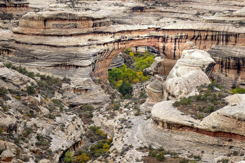
Days 26-27: Natural Bridges National Monument
Natural Bridges was one of the quietest stops on my Utah loop, and that is exactly why I loved it. The park is small, but it is home to three of the largest natural bridges in the world, each with its own character. The first time I drove the nine-mile scenic loop here, I stopped at every pullout and felt like I had the place to myself.
One of the biggest surprises was discovering that this was the first International Dark Sky Park in the world. I camped here on a new moon night, and the Milky Way was so bright it looked like clouds drifting across the sky.
Top Spots in Natural Bridges
- Sipapu Bridge: The largest of the three and the most impressive up close. The hike down is short but steep, with ladders and stairs built into the cliffside. Standing at its base made me feel like I had walked into a stone cathedral.
- Kachina Bridge: Massive and solid, with petroglyphs on its walls. The hike down is a little longer but worth every step.
- Owachomo Bridge: The most delicate-looking of the three and the easiest to reach. It is only a short walk from the parking area, so I like to visit here in the late afternoon when the light is warm and soft.
More to Explore
- Horsecollar Ruin: A short hike to an overlook where you can see a remarkably well-preserved cliff dwelling tucked into the canyon wall.
- Stargazing: Even if you do not camp, stay after dark if you can. The skies here are among the clearest I have ever seen, and you can often spot shooting stars without trying.
With only a few roads and trails, it is easy to see the whole park in a day, but I prefer to linger. The quiet, the views, and the sense of history make this place hard to leave.
Days 28-29: Monument Valley
Monument Valley feels like stepping into a movie you have seen a hundred times. The towering sandstone buttes rise straight out of the desert floor, their shapes instantly familiar from countless Western films. But being here in person is something else entirely.
The first time I drove the 17-mile Valley Drive, I stopped so often it took me almost four hours to finish. Every bend revealed a new formation, each one catching the light differently. The Mittens and Merrick Butte were glowing red at sunrise, while John Ford’s Point turned gold in the late afternoon.
This land is part of the Navajo Nation, and it holds deep cultural and spiritual meaning. Exploring it with a Navajo guide not only gave me access to areas off-limits to the public, but it also helped me understand the stories, traditions, and history behind these landscapes.
Top Experiences in Monument Valley
- Valley Drive: A self-guided loop past the park’s most iconic formations. A high-clearance vehicle is recommended, especially if it has rained.
- Guided Tours: Navajo-led jeep or horseback tours can take you to places like Mystery Valley and Hunts Mesa that are closed to the general public.
- John Ford’s Point: Named after the director who filmed here, this overlook is one of the best for photos, especially when the sun is low.
- Wildcat Trail: The only self-guided hiking trail in the park. It circles West Mitten Butte and offers a close-up look at the massive formations.
I like staying overnight in the area so I can catch both sunrise and sunset. The colors change so quickly here that it feels like a new landscape every hour.

Day 30: Return to Salt Lake City
After nearly a month of red rock cliffs, winding canyons, and open desert, the drive back to Salt Lake City feels like a slow exhale. You can take the fast route and be in the city by evening, or stretch the journey with one last scenic drive. I have done both, and each has its charm.
On one return trip, I followed Highway 191 north before cutting west on Highway 6. The road wound through mountain passes, past small towns where diners serve strong coffee and pie, and finally into the Wasatch Front. Another time, I took the longer way, stopping in Green River for a slice of melon in late summer and pulling over for photos of the Book Cliffs glowing in the afternoon light.
If your flight is not until the next day, spend your final night enjoying Salt Lake City. Walk Temple Square one more time, grab dinner at one of the city’s farm-to-table restaurants, or simply relax in a hotel room with a view of the mountains. After weeks of sleeping under desert skies, the quiet hum of the city feels almost surreal.
- Read also: My Guide to the Top Places to Live in Utah
Here are two routes to consider:
- Scenic Route: If you have time, consider taking a scenic route back to Salt Lake City. Highway 191 to Highway 6 offers beautiful desert and mountain landscapes. The drive takes about 6 hours, so plan for rest stops and photo opportunities along the way.
- Direct Route: For a quicker drive, take US-191 North to I-70 West, then I-15 North directly to Salt Lake City. This route is about 5.5 hours.
Can’t find affordable flights from Salt Lake City? If you’re willing to venture outside of the state, I recommend driving to either Las Vegas, Phoenix, or Denver for other great airports. Read my Southwest Road Trip article for more ideas on spots to visit throughout the region!

Things to Consider When Planning Your Utah National Park Road Trip
Before you pack up and hit the road, here are a few lessons I have learned from multiple Utah loops. These little details can make the difference between a good trip and one you will talk about for years.
Where to Start Your Road Trip
I always begin in Salt Lake City. The airport is easy to navigate, rental cars are plentiful, and you can stock up on supplies before heading into more remote areas. It is also a good way to adjust to the dry desert climate if you are coming from somewhere humid.
Best Time of Year
- Spring: Wildflowers bloom, waterfalls run strong, and the temperatures are comfortable. The weather can be unpredictable, so bring layers.
- Summer: The heat is intense in the lowlands, but early mornings and higher elevation parks like Bryce Canyon are comfortable. I plan hikes for sunrise and spend the afternoons exploring by car or relaxing in shade.
- Fall: My personal favorite. Cooler air, fewer crowds, and the fall colors in places like Capitol Reef and Zion add another layer of beauty.
- Winter: Quiet trails, snow-dusted red rock, and a peaceful atmosphere. Some roads and trails may close, so check conditions before you go.
Additional Destinations to Explore
If you find yourself with extra days, Utah has more than enough to keep you exploring.
- Fishlake National Forest: Home to the largest natural mountain lake in Utah. I once spent a whole afternoon here fishing and watching bald eagles circle overhead.
- Cedar Breaks National Monument: A natural amphitheater of red and orange cliffs at over 10,000 feet. Summer wildflowers here are incredible.
- Antelope Island State Park: Great for spotting bison, hiking, or simply watching the sun set over the Great Salt Lake.
- Dinosaur National Monument: Straddling the Utah–Colorado border, it is a paradise for fossil lovers. The Quarry Exhibit Hall has dinosaur bones still embedded in the rock.
- Snow Canyon State Park: Just outside St. George, with a mix of red rock, white sandstone, and old lava flows. The short hikes here are perfect for a half-day stop.
- Bonneville Salt Flats: A surreal, endless expanse of white. If it has rained recently, the flats turn into a mirror, reflecting the sky above.

FAQs About Utah National Park Road Trips
Here are some popular questions (and answers) about planning a road trip through Utah’s incredible national parks.
How much driving will I be doing on this trip?
On my full Utah loop, I usually end up driving between 1,500 and 2,000 miles total. Some days are short hops of one to two hours, while others are longer stretches of four to five hours. I like to plan the longer drives on days with lighter hiking so I can still enjoy the scenery without feeling rushed.
Can I do this trip without camping?
Absolutely. I have done it both ways. Utah has plenty of hotels, lodges, and vacation rentals near the parks, especially in towns like Springdale, Moab, and Torrey. You will want to book early, especially if you are visiting in spring or fall.
Do I need a 4×4 vehicle for this itinerary?
Most of the main national parks are accessible with a regular car or SUV. However, if you want to explore places like Cathedral Valley in Capitol Reef, the Maze in Canyonlands, or sections of Hole-in-the-Rock Road in Grand Staircase–Escalante, a high-clearance 4×4 makes things much easier and safer.

What should I pack for a Utah road trip?
I always bring layers since mornings and evenings can be chilly even in summer. Sturdy hiking shoes, a wide-brimmed hat, sunscreen, and a refillable water bottle are must-haves. I also carry a small cooler in the car for snacks and cold drinks.
How do I avoid crowds in the popular parks?
Starting early is key. I aim to be at the trailhead by sunrise for big hikes like Angels Landing or Delicate Arch. Visiting in the shoulder seasons of April to early June or September to October also helps.
Is there cell service in the parks?
Cell service is limited once you are inside most of the national parks. I download offline maps on Google Maps and AllTrails before leaving town. I also let someone know my hiking plans if I am going off the beaten path.
Do I need permits for any hikes or areas?
Yes, some spots require them. Angels Landing in Zion, Fiery Furnace in Arches, and certain backcountry routes in Grand Staircase–Escalante all need advance permits. Check the park websites before your trip so you are not caught off guard.

Global Viewpoint is a personal blog. All content is for informational and entertainment purposes only and does not constitute professional financial, medical, or legal advice.